Posts

Showing posts from February, 2020

Module 6: Georeferencing, Editing, & 3D

Image
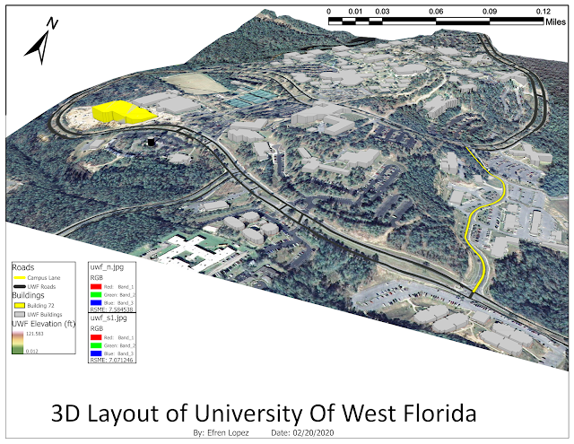
This weeks lab was pretty awesome, I learned how to make a 3-D map. Overall this week went smooth, I did not run into any major problems. Most of the work done was a test of what I have learned in past labs. I thought it was neat that I clipped building 72 and Campus lane from their original listings. That way I am able to individually change the symbology. Using the control points was also neat, this reminds me of Photoshop. although nothing ever lined up for me perfectly, but I figured that is normal since the picture gets distorted as more control points and higher order transformation is used.

Module 5: Geo-coding, Geo-referencing, and Basic Editing

Image
This week I learned about about Vector data and Raster Data. I also learned that Raster is faster and Vector is correcter! which is just an easier way to remind me the difference. Going over this weeks chapters really helped me understand last weeks lab more since we went over them in this lesson, for example going over the types of buffering and how it can be used made me understand exactly what this tool can do and what it is capable of doing in the right hands, this also applies to the Overlays when using vector data. being able to see each overlay with its description helped me connect with the past lab. Using excel was fun at first until I had to individually delete cells due to word map showing every other cell. Other than that, I managed to make everything work, I am starting to make a lot more mental connection with the application, Its starting to make sense. Transferring the excel sheet to ArcGIS was neat! Making my map available online was the cherry on top! That was the h

Module 4: Geo-referencing & Data Quality

Image
This week I learned what a hectares is, and I learned about queries, buffers, and overlays. Starting with the buffers on this map, I had no idea what exactly was the point of making all the buffers for the roads and water. Halfway through it started to come together, then I understood what was the point, its like pasting then cutting, and doing over while keeping the important information intact like the fields. I am familiarizing my self more every time I make a mistake and have to retrace my steps. My biggest mistake that took hours attempting to find was that the field where the inside road buffers and inside water buffers are in the buffer union's attribute table was showing null. I found out I did not do the field calculator correctly. This was the most challenging lab so far, as I am still a bit confused but I will not give up.

Module 3: Data Collection and Projections

Image
This week I learned about the different projections available and how they differ. I choose to include the legend in to the table so it would not look as cluttered. I centered the scale right above the table so the attention stays within that general area. In my opinion, If attention is drawn to the edge of the map instead of the center, it will overwhelm the map reader. I had fun using the ArcGIS Collector app it gave me reason to go out and move, it was nice to be able to go outdoors and still accomplish school work, I hope there is more activities like this in the future! I choose to locate fire hydrants around my area and ended up walking for about an hour since I could find any fire hydrants close by me. The whole process of pin pointing, taking pictures, describing the condition, uploading, and being outside was my favorite part of this weeks lab.